
Fort Hardy Park Resources
-

Annual Turning Point Parade & Festival
The Turning Point Parade & Festival commemorates the American Victory at the Battle of Saratoga on October 17, 1777, during the American Revolutionary War.
-

Lakes to Locks Passage: An Honorable Surrender
It’s believed under an elm tree in Fort Hardy Park, Burgoyne drew up and signed the Convention of Saratoga, which formally ended the Northern Campaign of 1777.
-

Experience Downtown Schuylerville Map
Come and experience our community on the water with this convenient, downloadable map of downtown Schuylerville.
-

New York State Canalway Water Trail
Try these paddling trips to explore canalways locally and throughout New York State. This website also contains virtual tours, lesson plans, and curriculum questions for the Erie Canal.
-

Friends of Fort Hardy Park Discount Card
Local businesses offer discounts when using this card. 100% of the proceeds go directly to helping the Friend’s mission. This card is a tremendous value.
-

PTNY's Bike Friendly NY
Bike Friendly New York administered by Parks & Trails New York is a free certification program that recognizes and supports businesses that offer services and amenities that accommodate cyclists.
-

Parks & Trails New York
Parks & Trails New York is a nonprofit dedicated to expanding, protecting, and promoting parks and trails across New York State to enhance outdoor recreation and community well-being.
-

PTNY Guidebooks
Parks & Trails New York offers comprehensive cycling guidebooks, featuring detailed maps, lodging and dining options, and highlights of historical and scenic sites along these trails.
-

Battles of Saratoga 250
Battles of Saratoga 250 is a commemorative initiative recognizing the 250th anniversary of the Battles of Saratoga, emphasizing their significance in the American Revolution through events, education, and community engagement.
Fort Hardy Park Timeline
-
According to historians, the Mohicans occupied this strategic crossing for millennia (artifacts date to the 1450s), using the intersecting waterways for trade and sustenance. The Hudson-Champlain corridor forms a near continuous water passage, extending from New York City and Quebec to the ocean and to the inland rivers and lakes. Tributary rivers flowing east and west provide access to New England and the Mohawk Valley of western New York. This waterway later became a major corridor for intertribal and European trade and warfare.
-
By the 1630s, the Mohicans had been driven from the Saratoga area by their long-standing enemies, the Mohawks.
From 1675-1678 was King Phillips War (aka The First Indian War) between New England settlers and Indians. This war was the beginning of colonialists defining their identity as Americans separate from Britian.
This land was granted to Philip Pieterson Schuyler who came from Amsterdam, Holland, in 1650. He died in 1684, the same year the Saratoga Patent to this territory was granted to his second son, Pieter Schuyler (Albany’s First Mayor, from 1686-1694).
-
King William’s War (aka the Second Indian War, and the first of six colonial wars between Britian and France) began in 1688.
Bartel Vroman was a documented pioneer settler of Old Saratoga as early as the year 1689. At a convention held at the city of Albany on Sept. 4, 1689, among others, it was "Resolved, That there be a fort made about the house of Bartel Vroman at Sarachtoge, and twelve men raised out of the two companies of the city and two companies of the county, to lie there upon pay, who are to have twelve-pence a day, besides provisions, and some Indians of Skachkook to be there with them, to go out as scouts in that part of the county."
In 1690, Major Peter Schuyler, then mayor of Albany, in command of some Dutch troops, built a blockhouse here for his military stores. A treaty was signed in 1697 ending the war.
-
The colonies were next embroiled in Queen Anne’s War in 1702 during which time Johannes Schuyler (grandfather of the general) improved his property on the south side of Fish Creek by erecting mills and inducing families to farm.
Confirmed by the Colonial government in 1708, the patentees of the area are listed as Peter Schuyler, Robert Livingston, Dirck Wessels, John Johnson Bleecker, Johannes Schuyler, and Cornelius Van Dyck.
Construction of mills in the area occurred between 1709-1710. In 1709, Peter Schuyler, now a colonel in the service, built a stockaded fort on the east side of the river on the high bluff a hundred rods below the mouth of the Batten Kill. Old Fort Saratoga stood for nearly forty years.
-
On November 18, 1745, a settlement of thirty families by the Schuyler Mills was attacked and Peter Schuyler was killed.
Old Fort Saratoga was abandoned and burnt by the retiring English troops in the autumn of 1747.
Fort Hardy was built from 1755 - 1757 during the French and Indian War by the British as part of the campaign against the French to guard a ferry crossing. Named for Sir Charles Hardy, royal governor of New York. 1755- Construction of blockhouse, 1756 – Construction of earthworks enclosing approximately 15 acres, 1757- Demolition of blockhouse & construction of brick and stone fort. 1758 – 16,000 troops camp at Fort Hardy.
-
The Schuyler house and mills were rebuilt soon after peace was declared between Britian and France in 1763, bringing increased settlement to the area.
1765 - The American Revolutionary War begins.
A grist-mill was erected on the north side of Fish creek and in 1767 Phillip Schuyler (Philip Pieterson Schuyler’s great grandson) erected a flax linen mill, the first of its kind in the American colonies. The area flourished as a center of lumbering, farming, fishing, and merchandising.
Five barracks buildings still standing from the abandoned Fort Hardy were used as late as 1771 as homes.
By October 1777, more than 10,000 troops were active in the area that now includes the Village of Schuylerville. British forces led by General Burgoyne were stopped briefly on October 11th near the ruined fort in a brief but intense conflict as part of the larger Battles of Saratoga. On October 17th, 1777, Burgoyne surrendered his army when he signed the Articles of Convention. The location where the British gave up their weapons is now known as the Field of Grounded Arms. Of 6,902 rank and file soldiers, plus an unknown number of officers who crossed the Hudson, 5,804 were made prisoner, a loss of over 1,000 soldiers.
-
The first store in Schuylerville was probably kept by Abraham Van Deusen, opened soon after the War of 1812.
From 1817-1823 was the construction of the Champlain Canal. The construction of the canal was approved April 15, 1817 (the same day construction of the Erie Canal began near Rome, NY.
1831 – Community incorporated and given the name Schuylerville.
1836 – Privately financed toll bridge across the Hudson River opens.
1839-1840 George Strover purchased the Schuyler House.
-
D.A. Bullard & Sons constructed the Schuylerville Paper Plant in 1863.
1866 - The Schuyler Yacht Basin was established.
October 17, 1877 – Centennial of the Surrender, cornerstone of Saratoga Monument laid by the Grand Master of the Masonic Grand Body of the State of New York. Granite work completed 1883.
-
1902 – Driving Park established at Fort Hardy Park.
1903 - Village installed water system.
1912 - Fort Hardy was the training ground for the 10th US Calvary Buffalo Soldiers.
1913 – Disastrous flood leads to building of present bridge across the Hudson River by the State.
1921 – The Villa Family (who owned the Tripoli hotel and a Ferry Street grocery store donated baseball grandstands.
1926 – Historical Pageant is held at the park.
1934 – The Works Progress Administration (WPA) establishes Fort Hardy bathing beach.
1938 – Village installs sewer system.
-
1950s – Little League is established on the fields.
1990s – Youth Center constructed.
-
2002 – 225th Anniversary Celebration of the Battle of Saratoga and Fort Hardy as the “Field of Grounded Arms”
2009 – 2018 Dredging and subsequent habitat rehabilitation along 200 miles of the Hudson River, designated the world’s largest Superfund site, largely due to General Electric’s dumping of an estimated 1.3 million pounds of polychlorinated biphenyls (PCBs) into the Hudson River between 1947 and 1977.
2019 – The Empire State Trail connecting Manhattan to Canada is completed adjacent to Fort Hardy Park along the Old Champlain Canal Tow Path.
2021 – The Canal Region Visitor Center opens.
Learn More
Click one of the buttons below to jump to that section, or scroll through to learn the full history!
Fort Hardy Park Early History
“It is thus evident that Saratoga Lake, its outlet (Fish Creek) and the river below that point, were regarded as places of great importance by the aborigines of that period. As the streams afforded the only natural highways of the country, the Hudson, Lakes George and Champlain, were the routes by which all communication was had between the hostile settlements.”
“The fertility of her soil, the beauty of her scenery, and the utility of her great water courses and falls, early attracted the sagacious and enterprising European,” said Gen. E.F. Bullard, in the History of Saratoga, an address delivered at Schuylerville, July 4th, 1876 and reprinted in The Saratogian, July 20, 1876.
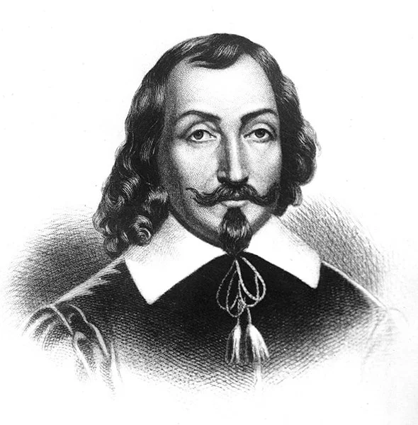
Samuel de Champlain, Britannica Image.
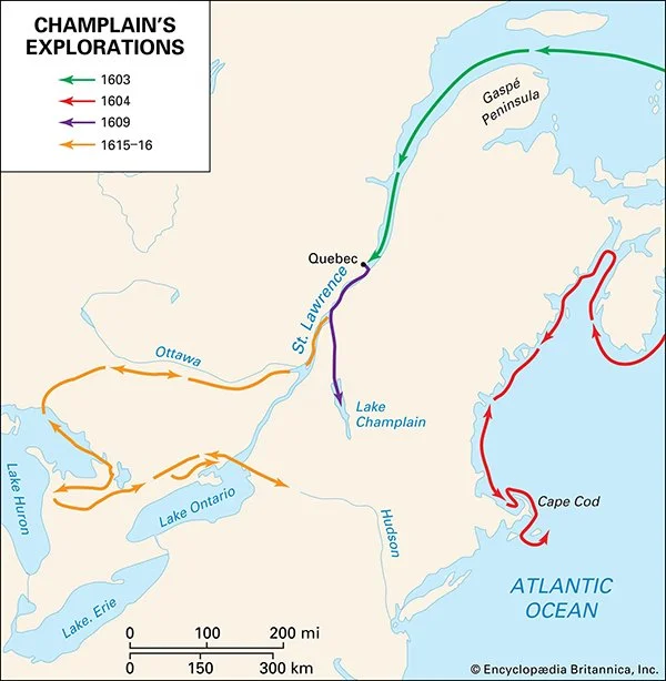
Champlain’s Explorations, Britannica Image.
Samuel de Champlain, the first European known to have set foot upon our northern boundaries, travelled down the St. Lawrence River, under the authority of the French, on the 4th day of July, 1609.
On Sept. 2nd, 1609, Hendrick Hudson, dropped anchor at what he called the Grande Noordt River (Grand North River, later named the Hudson River).
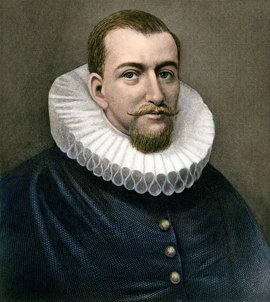
Henry Hudson, Britannica.

Landing of Henry Hudson 1609 at Verplanck Point New York by Robert Walter Weir. 1835. Wikimedia Commons.
In communications between Thomas Dongan, the Royal Governor of this colony, with the Mohawks on November 4th, 1684, this area was called “Serachtague”.
“From this time onward, for the next century, this locality was destined to be the great battle ground between the opposing forces of civilization, which were then contending for the mastery of the human race. At this period no district, town or country had been organized under the name of Saratoga, but the whole country along the river, on each side to a considerable distance, was known under that general name,” continued Bullard.

Thomas Dongan, Wikipedia.
“The first legal title to the land here from a civilized government was granted October 29, 1708, by Lord Cornbury, the governor of this colony, to Peter Phillip Schuyler, Robert Livingston, Derick Wessells, John Johnson Bleecker, Johannes Schuyler, and Cornelious Van Dyck. It began on the west side of the Hudson river, at the south side of the mouth of the creek called “Tionooudehowee,” (now at the village of Mechanicsville) and extended north to the mouth of the creek on the east side of the Hudson River, called “Dionoondehowee,” (now called the Batten Kill) about one mile north of Schuylerville, and extending six miles on each side of the river, except that the portion on the east side of the river was bounded south by the Hoosic patent.”
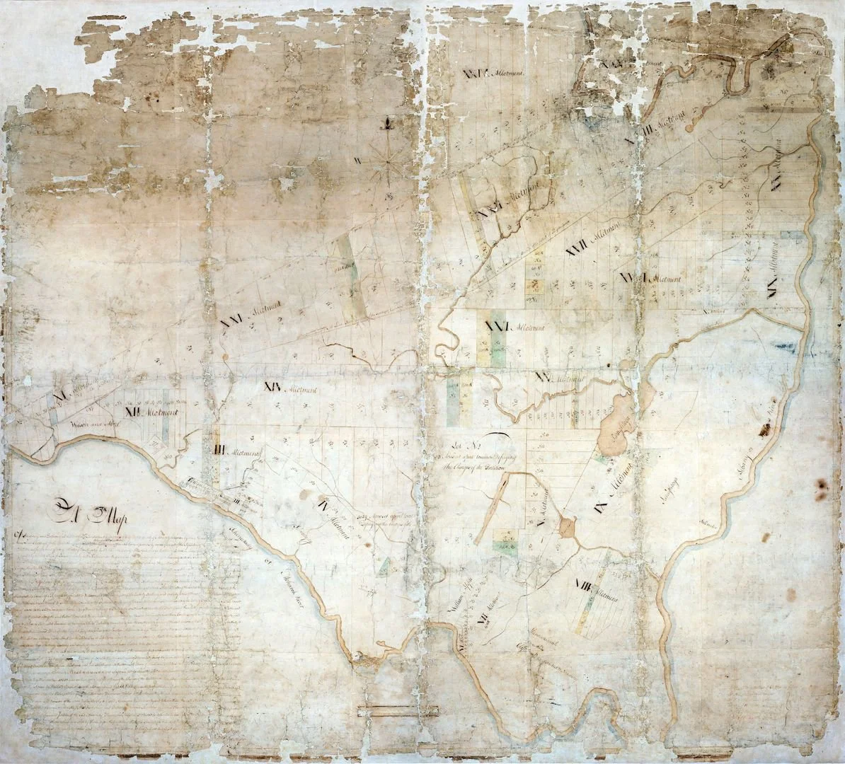
Saraghtoga Patent Section IX. Stillwater Library.
The land was described as “204 square miles, or over one hundred and thirty thousand acres, of the finest land on the continent”. The Schuyler’s erected buildings and mills in 1708.

Schuyler Mansion Number 2, The Story of Old Saratoga by John Henry Brandow, M.A., 1919.
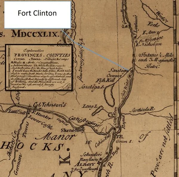
In 1709, a British force of 1,500 soldiers along with 600 Mohawk warriors, cut a road through the forest which began at Schuylerville on the east side of the Hudson River, and extended northward to Fort Edward, then followed Wood Creek to Whitehall.
Along this road, three forts were constructed – Fort Anne, Fort Nicholson, and Fort Saratoga. Fort Saratoga was located on a hilltop across from Schuylerville. It was described as having a square wooden outline with log palisades and officer barracks at the corners. They were “constructed wholly of timber and were similar to the other stockade fortifications of the country at that period – affording an effectual defence against any attack of musketry, but incapable of withstanding artillery.” (Pehr Kalm. 1769).

Destruction of Schenectady, New York Public Library.
In November 1745, the Village (then on east side of the river by the fort) was destroyed by the French and Indians from Fort St. Frederic (at Crown Point) in the First Battle of Saratoga. The forces attacked the village, burning 30 houses, several mills, and the fort. In the raid, more than 100 soldiers, residents, and slaves were killed, scalped, or captured.
“This attack was made by the Indians and French at the dead hour of night, without warning, and many persons killed and 109 captured and taken to Canada. The fort was destroyed; every house burned, and every building except one saw mill which was not discovered.”
Old Fort Saratoga, which stood for nearly forty years, was abandoned and burnt by the retiring English troops in the autumn of 1747.
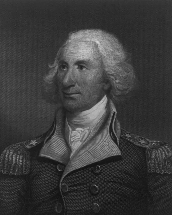
General Philip J. Schuyler as depicted by J. Trumbull Library of Congress.
Early Forts Near Old Saratoga: Some History, New York Almanack.
Colonel Philip Schuyler was the driving force behind the rebuilding of Fort Saratoga into what would become known as Fort Clinton.
While re-construction likely followed the footprint and plans of the original, the larger garrison force introduced later in 1746 required an expansion and improvements to the fort.
As part of the expansion, the former blockhouses were left within the curtain wall, creating a rectangular plan with six bastions and a large detached storehouse.
Shortly its construction, the entire fort was burned and destroyed by the English as they retreated southwards to the protection of Albany and Schenectady.
Construction of Fort Hardy began in 1755.
The Building Fort Hardy Park
At the time of its building, Upstate New York was not an area as settled and “civilized” as Southern New England. This was still “hostile territory” where very few would risk their lives on what was then a great highway for the passing of Native American armies.

1776 Sauthier A Topographical Map of Hudson’s River.
Fort Hardy was constructed in stages from 1755 to 1757 by the British as part of the campaign against the French in the upper Hudson Valley during the French and Indian War.
Located on the Hudson River at the mouth of Fish Creek, Fort Hardy guarded a ferry crossing and was named for Sir Charles Hardy, Royal Governor of New York.

New York Public Library. 1760.
The same year, Fort Hardy’s builder, Colonel James Montressor, chief of the Royal Engineers in the Provinces, was commissioned to build forts at Albany, Schenectady, Halfmoon, Stillwater, Fort Edward, and Fort George on Lake George. He began work on Fort Hardy August 19th, 1757. By the 7th of September, approximately a hundred men and six teams of oxen were at work on the project.
“Built by whip-saws run by hand power. The stone was drawn from the hills, presumably from the ridge west of the old north burying ground, as old residents say loose stone was most plentiful there. The brick was brought down from Fort Edward in bateaux, or scow boats. Thus, early Fort Edward had its brick yards. The timber was procured up the river on both the mainland and islands, floated down and dragged out with ox teams. The first buildings finished were three storehouses, which were placed on posts three feet high to preserve the stores from water in case of inundation. The capacity of the three was 2,596 bbls. of flour. The barracks for the soldiers were 220 feet long; the officers' rooms were 14x16 feet in size. One day the mechanics all struck work because the commissary tried to put them off with a gill of rum instead of their regular ration: The trouble was that " the jug was out."
– Fort Hardy Park Presentation by Tom Wood with info from The Story of Old Saratoga, By John Henry Brandow. 1919.

Portrait of Col. James Gabriel Montressor. Wikipedia.
The fort had a distinctive line of trees along the bank of the Hudson River and another section along the river bank had a sawtooth palisade adjacent to the gate (an unusual aspect to Fort Hardy).
The blockhouses on the western side and defenses on the southeast portion are often considered by modern researchers to be the “core” of the fort, but the earthworks were also integral as they provided safe camping ground for troops in transit to and from the active campaign areas to the north.

1757 Montressor Plan of the Fort at Saratoga.

1763 Rocque A Plan of the Fort at Saratoga.
In this reconstruction, the earthworks, rampart, and a deep ditch (over which was a drawbridge) are present, as are the structures within the fort, such as the magazine, gate, blockhouses, and other buildings. “Two barracks, not very large, but well-built, with brick chimneys, were located on the outside of the perimeter ditch to the south”. (New York Almanack, 2023)
The postholes for facine anchors were found in a 2007 excavation (Stall, Rogers, and Batruch, Finding Fort Hardy) These bundles were attached to the earth with spikes and anchors buried in the rampart. Because these bundles were small and held in place by buried ropes and posts, the structural stability of the fort was limited to the period that these elements were intact, prior to their decay. Once the cords and bundles rotted away, the earthworks would slump and the ditches would fill with earth from the eroding ramparts. (Griswold & Linebaugh, The Saratoga Campaign)
Fort Hardy was never attacked during the French and Indian War, and was abandoned when peace returned. Five barracks buildings still standing at Fort Hardy were used as late as 1771 as homes by local residents (Strach 1986).

Closeup of 1777 Faden Plan of the position which the army under Lt. Genl. Burgoyne took at Saratoga.

The Saratoga Campaign. 2016.

The Burleigh Lithograph.
A Day Famous in the Annuals of History: The British Surrender of October 17th, 1777
In Richard Ketchum’s 1997 tome, Saratoga – Turning Point of America’s Revolutionary War, he cites a journal entry from Lieutenant William Digby, of the British 53rd Shropshire Regiment of Foot.
The extra-large heading read; “A day famous in the annuals of America”.

NY State Historical Marker, Schuylerville, NY.

After the Battles of Saratoga (which today, are on lands within the Villages of Schuylerville and Stillwater) the lack of provisions, cold rains, and persistence of the American troops resulted in British General John Burgoyne agreeing to the terms of a surrender.

Informational Marker at Saratoga Monument Trail, Schuylerville, NY.

Library of Congress.
Beginning at ten o’clock, the final parade of General John Burgoyne’s army marched to the grounds of Fort Hardy, colors flying, fifes and drums playing.
In just three months, their force had dwindled by a third.
Soldiers, along with 300 women, and a ragtag collection of surgeons, chaplains, adjustants, quarter-masters, and engineers (all in tattered uniforms or whatever clothing they could piece together) marched, accompanied by pet deer, raccoons, and other wild animals, toward the Hudson River to surrender their weapons.

Stock Image.
“The importance of this event, even at the end of a century, cannot be fully comprehended. Eminent authorities have pronounced it one of the greatest battles known in human history, when measured by its far-reaching consequences. It was the first great success of the people struggling for self -government against the prestige of king craft and despotism. It has been well said, that without this result at Saratoga, Bunker Hill would have been insignificant and Yorktown an impossibility. Great and crushing as was the defeat at Saratoga, the war was not yet ended, and the struggle continued for five years longer. Nor did this locality escape the trials and hardships of those times which tried men’s souls.”
– “History of Saratoga – Address by Gen. E.F. Bullard, Delivered at Schuylerville, July 4th 1876”. The Saratogian, July 20, 1876.

Jacob Coyle Letter. Schuylerville Public Library.

“History of Saratoga”, The Saratogian. 1876.

Stock Image.
For the 5,895 British and German soldiers who laid down their arms that morning (in what is now Fort Hardy Park), it was a “bitter rendezvous with reality”, says Ketchum.
“All hail thou morning of the 17th of October 1777! Light from the four corners of heaven streams upon thee, making thee, the brightest that had yet dawned upon this virgin continent,” said Reverand John Henry Brandow, A.M., in The Story of Old Saratoga (1919).
“Farewell, ages of tyranny; farewell sceptered brutes and crowned despots! The triumphant day here dawned which ultimately assured to every man the privilege of becoming equal to any other man, and which should see every man anointed a king and every woman a queen in her own right, and ushered in the era that should witness the realization of that dream of the poet: The parliament of man, the federation of the world.”

General Burgoyne, Wikipedia Commons.
On the grounds of Fort Hardy, a French and Indian War ruin, the decaying corpses of horses littered the landscape, imbuing it with the stench of death.
“The consequences were undeniable: France entered the war on the American side. When Washington and his ragtag army, wintering in Valley Forge, Pa., received news of the alliance in the spring of 1778, their spirits were lifted; the road was open to ultimate victory in October 1781… Saratoga… launched two centuries of revolution elsewhere. It marked the beginning of the end of the British Empire. And it breathed life into the United States of America…We had passed through the baptism of blood, and had gained a name among the nations of the earth,” said The New York Times chief correspondent R.W. Apple Jr., in an New York Times Magazine article that ran May 9, 1999.

Story of Old Saratoga by John Brandow. 1919.
“The artillerymen parked their cannon while infantrymen emptied cartridge boxes and stacked their muskets, but the experience was too much for a few drummers, who stomped holes in the skins of their drums, while some angry foot soldiers smashed the butts of their muskets and threw them on the piles,” wrote Digby.

Saratoga: Turning Point of America's Revolutionary War, Richard M. Ketchum, 1999.

Turning Point Parade, Schuylerville, NY.
The stark silence was broken by the jubilant singing of “Yankee Doodle” as the waiting Americans lined up to watch the parading prisoners traverse the torn-up earthen road (that had seen more than 15,000 pairs of feet, scores of horses, wagons, and gun carriages in the past two weeks).
“Brigade by brigade, regiment by regiment, the British and Brunswickers paraded through this gauntlet, their jaws tight with anger and pride, arms swinging freely now that they had no weapons to carry, seeing for the first time, the face of destiny.”
After the surrender, there was a memorable feast “where planks laid on barrels held food – a ham, a goose, some beef, and boiled mutton”.
Hard Cider and watered-down New England Rum were at the ready - the two commanders got glasses, but the others drank from stainless steel mugs.
The defeated British army then marched across the ford at Fish Creek, past the burned remains of the Schuyler buildings.

Soldier’s Monument in Prospect Hill Cemetery, Victory, NY.
“The terms of the surrender were “embarrassingly lenient” says George C. Daugban in his book, Revolution on the Hudson.” – New York City and the Hudson River.

New-York Historical Society Museum & Library.
After signing the “Articles of Convention between Lieutenant General Burgoyne and Major General Gates,” the American forces held nearly 6,000 prisoners, thirty pieces of artillery, and more than 4,500 muskets and accompanying ammunition. The weapons were distributed to the American military forces, and the prisoners were marched to Cambridge, Massachusetts, just outside Boston, for an intended return to England. (Terms of the convention required that the soldiers were not to return to fight in the war again, and Congress demanded a list of names of the soldiers to confirm British compliance with the convention. When this was refused, Congress declined to honor the return article.)
Some of the captured troops were sent to England, including Burgoyne and some of his officers, while others were kept confined and eventually marched to the Albemarle Barracks outside Charlottesville, Virginia.
According to Burgoyne, five or six hundred soldiers deserted and became day laborers or tradesmen, with a few attempting to rejoin the British army under Generals William Howe or Henry Clinton.

The Surrender of General Burgoyne by John Trumbull. 1821. Hangs in the US Capitol rotunda in Washington, D.C. Wikipedia Commons.

“History of Saratoga”, The Saratogian. 1876.

NY State Historical Marker, Schuylerville, NY.
The surrender of the British army (then considered the mightiest in the world), to the Army of the United States was the Turning Point of the Revolutionary War as it brought a powerful new ally, France, along with their supplies and funds, to side of the American cause.
“The importance of this event, even at the end of a century, cannot be fully comprehended. Eminent authorities have pronounced it one of the greatest battles known in human history, when measured by its far-reaching consequences. It was the first great success of the people struggling for self-government against the prestige of king craft and despotism. It has been well said, that without this result at Saratoga, Bunker Hill would have been insignificant and Yorktown an impossibility. Great and crushing as was the defeat at Saratoga, the war was not yet ended, and the struggle continued for five years longer.”
– “History of Saratoga – Address by Gen. E.F. Bullard, Delivered at Schuylerville, July 4th 1876”. The Saratogian, July 20, 1876.
After The Surrender
After the Revolutionary War, the rebuilding began.
“Nor did this locality escape the trials and hardships of those times which tried men’s souls. The march and counter-march of this hostile army with its barbarous allies, had completely desolated the whole region hereabouts. This country had been richly laden with the golden harvest and domestic animals for the use of the husbandman.”

The Siege of Gibraltar, 1782 by George Carter. Wikipedia Commons.

Philip Schuyler's Sawmill. The Old Saratoga Historical Association calendar.
“After the surrender, the farmers gradually returned to their rural homes, erected new log houses, and began again to till the soil. But little progress, however, was made, as this valley lay in the track of the Indians and tories who had fled to Canada, and made repeated raids into this country.”
– History of Saratoga – Address by Gen. E.F. Bullard, Delivered at Schuylerville, July 4th 1876”. The Saratogian, July 20, 1876.

Illustration of Sir William Johnson's visit to High Rock Spring. Bolster Collection.
In 1783 Gen. Schuyler first cut a road from Schuylerville to Saratoga Springs, where he built the first frame building in 1784. On February 7, 1791, Saratoga County was legally formed and named.
The turn of the century brought prosperity to the region with the completion of the Champlain Canal in 1823. In 1831, the community was incorporated and given the name Schuylerville, after its most prominent family.
“Time, and the spirit of the American people to move forward into new field of enterprise, have, here as elsewhere, worked mighty changes,” continued Bullard.

Schuylerville Cotton Factory. The Old Saratoga Historical Association calendar.

DA Bullard & Sons Paper Mill. The Old Saratoga Historical Association calendar.
“Then the soil wild and mostly uncultivated; now blooming like the rose, and affording abundance of grains and fruits to make glad the heart of city fixed man. Then the streams located here by a beneficent Creator, were running to waste. Now, harnessed by man’s intellect, they are doing the work of a thousand hands. Then the fort and the army demanded the exertions of the public. Now, the arts of peace are flourishing around us, while the education of our children and the development of the races, demand the best thought of mankind. Then the romance and horrors of war were familiar to every ear. Now we feel confident that those days have gone by forever, so far as our people are concerned, and the time is now here when we can safely beat the sword into the plowshare, and the spear into the pruning hooks.”

1889 Schuylerville Lithograph by LR Burleigh.